Coldest air yet this season to be unleashed across midwestern US as October begins
Residents of the Midwest may be wondering what month the calendar flipped to later this week, as a November-like air mass plunges in with gusty winds, spotty showers and perhaps even some snowflakes.
Following a modest cooldown which will push high temperatures 5-10 degrees Fahrenheit below late-September averages early this week, the region will see a more drastic cool-down for the second half of the week.
 |
By Thursday and Friday, cities from Grand Forks, North Dakota to Cincinnati be plunged into conditions more typical of Halloween or early November.
Heating demands are likely to ramp up, and jackets and sweatshirts will be needed attire for those that venture outdoors.
While average temperatures are beginning their rapid descent at this point in the year due to the decreasing sun angle and shorter amount of daylight, the magnitude of this cold spell is still likely to be significant in terms of departures from normal. However, forecasters say record cold is not in the cards.
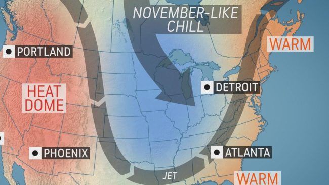
An amplified jet stream pattern will set up across the country this week, with a northward bulge bringing intense heat to the West and a southward dip allowing for chilly waves farther east.
 |
“Temperatures will be 10-20 degrees below normal across the Upper Midwest and western Great Lakes by Friday, and then widespread highs of 10-15 degrees below normal will occur Saturday across the Great Lakes, Midwest and Ohio and Tennessee valleys,” AccuWeather Senior Meteorologist Dan Pydynowski said.
This will put daytime highs mainly in the 50s F over the Midwest, with some 40s likely over the northern tier during the second half of the week. Factoring in a biting wind, extensive cloud cover and spotty showers in some cases, AccuWeather RealFeel® Temperatures will be in the 40s and even the 30s at times.
 |
“AccuWeather RealFeel® Temperatures will struggle to get out of the 40s in Chicago on Friday despite some sunshine,” Pydynowski said.
Given the magnitude of the cold air spilling over the still warm Great Lakes, it is not out of the question for waterspouts to form. In addition, any heavier showers could contain graupel, or soft hail.
CLICK HERE FOR THE FREE ACCUWEATHER APP
“With this blast of cold air, the first snowflakes of the season may fly across the Arrowhead of Minnesota into parts of the Upper Peninsula of Michigan and northern Wisconsin, inland away from the shore of Lake Superior on Thursday into Friday,” Pydynowski said.
“By the weekend, the chill will also begin to reach the Eastern Seaboard with highs a general 5-10 degrees below normal from Georgia and the Carolinas northward into D.C., Baltimore and Philadelphia,” Pydynowski said.
The eastern part of the country will first have to contend with rounds of drenching rain into the middle of the week before the chill lunges into the region.
Keep checking back on AccuWeather.com and stay tuned to the AccuWeather Network on DirecTV, Frontier and Verizon Fios.


